
今回もNano Banana 2の力を試したいと思います。テーマは、「路線図」です。
東京地下鉄路線図を作成してください。
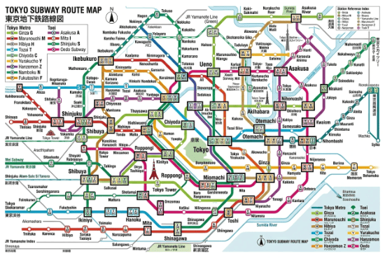
これが正しいのかどうかは詳しく調べていませんが、画像とてしては良い感じです。テキストは日英混在になりました。生成時間はとても短かったです。
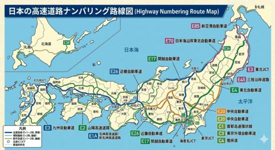
日本の高速道路ナンバリング路線図を作成してください。
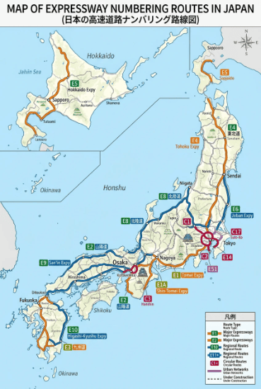
ナンバリングは正しいようです。主要な高速道路のみの生成となりました。テキストは日英混在です。日本語の方はかなり崩れています。1回目の生成時は、94%から進まず、5分以上たってからシステムキャンセルになりました。この挙動は前バージョンから変わっていないようです。94%で止まったら手動キャンセルした方が時間の無駄になりません。
新幹線路線図を作成してください。テキストはすべて正しい日本語で表記してください。
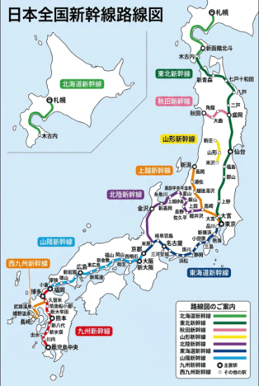
とても見やすい路線図になりました。
Nano Banana 2
・テキストについては、『テキストはすべて正しい日本語で表記してください。』というプロンプトが不可欠なようです。
・地下鉄路線図はかなり複雑なものを生成していて、一見すると正しそうです。しかし、高速道路路線図はかなりアバウトになりました。ひとくくりに「路線図」と言っても簡単なプロンプトでよい場合もあれば、詳細なプロンプトが必要な場合もあるようです。
参考生成
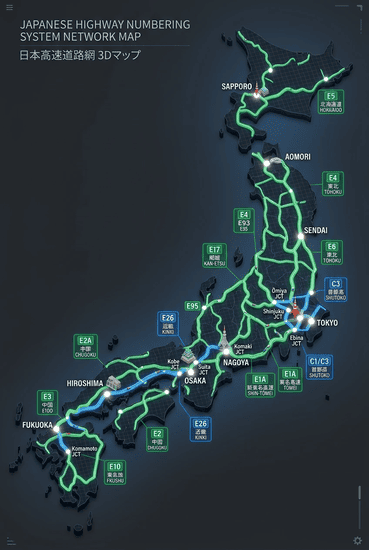
Gemin3+Nano Banana 2/高速モード
日本の高速道路ナンバリング路線図を作成してください。テキストはすべて正しい日本語で表記してください。
SeaArt版Nano Banana 2
Japanese Highway Numbering System Network Map, 3D Render style, clean and simplified isometric visualization.
Subject: A detailed, yet clean and highly organized 3D digital visualization of the entire Japanese nationwide expressway network, including major routes (E1 to E99), connecting roads, and significant urban ring roads (C3, etc.). The map covers the entire archipelago of Japan. Routes are depicted as extruded 3D tubes or lines with glowing highway numbering shields (green and blue, e.g., “E1”, “E23”, “C3”) and Japanese/English text labels for major cities, prefectures, and important interchanges, all in a uniform, modern, and sharp font (e.g., Tokyo, Osaka, Nagoya, Fukuoka, Sapporo, Shinjuku JCT).
Action & Relationship: Each highway route is a distinct, glowing 3D path, interweaving and connecting with other routes and junctions, forming a complex but clear network. The physical 3D structure itself is the map, with varying line thicknesses representing major/minor routes. Tiny, illuminated dots mark major junctions and cities. All elements are organized for maximum readability, with clear hierarchical representation.
Setting: A clean, minimal, digital display or interactive kiosk interface context. The map is set against a subtle, dark gradient background (e.g., charcoal grey to deep blue), mimicking a modern command center or smart city display. A few small, stylized, geometric icons of iconic Japanese structures or landmarks (e.g., Tokyo Tower, Mt. Fuji, Osaka Castle) are subtly integrated near their respective cities, rendered in the same clean 3D style.
Style & Medium: A high-quality, modern, digital 3D isometric render, but viewed from a direct overhead or perfectly straight-on orthographic perspective to ensure all text and lines are flat and readable. It should look like a physically real but highly stylized, illuminated architectural model or a advanced holographic interface. The materials are semi-transparent with glowing internal lights for the routes. No perspective distortion.
Composition & Camera: Flat, orthographic top-down view. The entire nationwide map is centered and framed perfectly within the image. All elements, including the furthest regions, are in perfect focus (deep depth of field). All labels, shields, and route lines are perfectly vertical or horizontal relative to the frame (orthographic), and razor-sharp.
Lighting & Color: Clean, precise digital lighting. The map glows with colors: routes in official Japanese highway colors (expressway green for national, blue for regional/urban). The background is dark, and the routes are the primary light source, with a soft, uniform glow. The text labels are crisp white, with Japanese characters and English names below. A clear color-coded legend is included.
Quality & Detail: Extremely high resolution and razor-sharp clarity. All text, including the smaller city names and highway numbers, is legible. The texture of the 3D routes is polished, with very clean lines and no compression artifacts. The background is a clean, minimal gradient without clutter. The details of major interchanges are visible but simplified.

コメント